Madhya Pradesh Forest Map - File Information
| Map Name | Madhya Pradesh Forest Map |
|---|---|
| Available Formats | WEBPPDFJPGPNG |
| WEBP Size | 0.28 MB |
| PDF Size | 0.07 MB |
| JPG Size | 1.06 MB |
| PNG Size | 3.33 MB |
| No. of Pages in PDF | 1 |
| Image Height | 2082 Pixels |
| Image Width | 2947 Pixels |
| Category | Geography |
| Related | Madhya Pradesh |
Madhya Pradesh Forest Map - Preview
 Preview in Large Size
Madhya Pradesh Forest Map - Summary
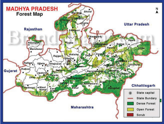
Forests of Madhya Pradesh cover around 95,221 sq kms area of the state. This area has been classified into ‘Reserved Forest’, ‘Protected Forest,’ and ‘Unclassified Forest’. Variability in climatic conditions brings about significant differences in the forest types of the state. There are four important types of forests, namely Tropical Moist, Tropical Dry, Tropical Thorn, and Subtropical broadleaved Hill forests.
The forest area can also be classified on the basis of the composition of forest terrains. Based on composition, there are three important forest formations, namely Teak forest, Sal forest, and miscellaneous Forests. Bamboo-bearing areas are widely distributed in the state of Madhya Pradesh. The central, southern, and eastern parts of Madhya Pradesh are rich in forests, while the western and northern parts are comparatively deficient in forests.
MP Forest Cover Map
Madhya Pradesh Forest Map - Download Links
- WEBP 0.28MB
- PDF 0.07MB
- JPG 1.06MB
- PNG 3.33MB