Gorakhpur to Siliguri Expressway Route Map - File Information
| Map Name | Gorakhpur to Siliguri Expressway Route Map |
|---|---|
| Available Formats | WEBPPDFJPGPNG |
| WEBP Size | 1.16 MB |
| PDF Size | 6.71 MB |
| JPG Size | 3.27 MB |
| PNG Size | 12.19 MB |
| No. of Pages in PDF | 1 |
| Image Height | 3576 Pixels |
| Image Width | 2526 Pixels |
| Category | Geography |
| Related | Uttar Pradesh |
Gorakhpur to Siliguri Expressway Route Map - Preview
 Preview in Large Size
Gorakhpur to Siliguri Expressway Route Map - Summary
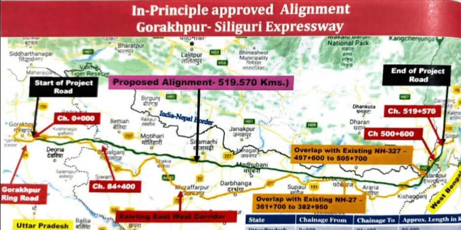
Gorakhpur – Siliguri Expressway – Information & Status- 519 km Gorakhpur – Siliguri Expressway by NHAI is a proposed 4 lane access-controlled highway with a route alignment connecting Gorakhpur in Uttar Pradesh and Siliguri in West Bengal. This greenfield expressway under Bharatmala Pariyojna (BMP) Phase 2 will run parallel to the Nepal Border and connect 3 states of Uttar Pradesh, Bihar (majority) and West Bengal.
Gorakhpur to Siliguri New Expressway Route Map
Gorakhpur to Siliguri Expressway Route Map - Download Links
- WEBP 1.16MB
- PDF 6.71MB
- JPG 3.27MB
- PNG 12.19MB