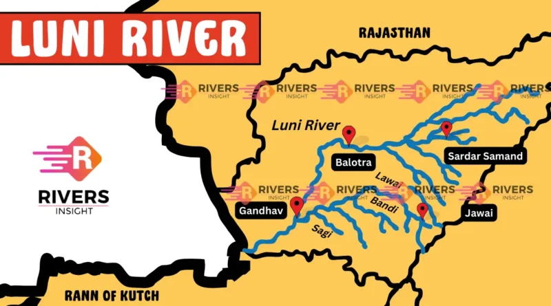
Luni River in India Map - File Information
| Map Name | Luni River in India Map |
|---|---|
| Available Formats | WEBPPDFJPGPNG |
| WEBP Size | 0.25 MB |
| PDF Size | 0.52 MB |
| JPG Size | 0.95 MB |
| PNG Size | 2.31 MB |
| No. of Pages in PDF | 1 |
| Image Height | 2754 Pixels |
| Image Width | 3564 Pixels |
| Category | India |
| Related | Indian Rivers Map |
Luni River in India Map - Preview
 Preview in Large Size
Luni River in India Map - Summary
Luni River is located in Rajasthan, western India. It originates on the western slopes of the Aravalli Range near Ajmer, where it is referred to as the Sagarmati. The river generally flows southwestward, traversing the region’s hills and plains before entering a desert area. It ultimately dissipates into the northeastern section of the Rann of Kachchh (Kutch) marsh in Gujarat.
As a seasonal river, it captures a significant portion of the drainage from the southwest slopes of the Aravalli Range. Its primary tributaries are the Jowai, Sukri, and Jojari rivers.
The name Luni is derived from the Sanskrit term lavanavari, meaning “salt river,” which reflects its high salinity. Spanning approximately 330 miles (530 km), the Luni is the only significant river in the region and plays a crucial role in providing irrigation water.
Luni River Map and Tributaries

Luni River in India Map - Download Links
- WEBP 0.25MB
- PDF 0.52MB
- JPG 0.95MB
- PNG 2.31MB