Tikamgarh Development Master Plan 2031

| Formats | WEBPPDFJPGPNG |
|---|---|
| Height | 2384 px |
| Width | 3600 px |
| Related | Madhya Pradesh Master Plans |
Download High resolution Madhya Pradesh Master Plans Maps in JPG, PDF and PNG formats for free.
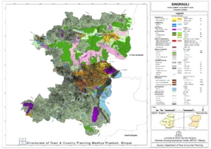
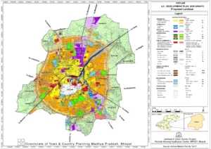
Madhya Pradesh Master Plan maps are a crucial component of this planning process, providing a detailed overview of land use, infrastructure and development goals for each district and municipality in the state. These maps are designed to help planners, developers, and policymakers make informed decisions about zoning, transportation, and other key issues that affect the quality of life for residents and the overall economic health of the region.
Madhya Pradesh Master Plan maps are available in a variety of formats, including digital maps and GIS ( Geographic Information System) data. They are often used by developers, real estate professionals and other stakeholders to assess market opportunities and identify potential areas for investment and development.
| Formats | WEBPPDFJPGPNG |
|---|---|
| Height | 2384 px |
| Width | 3600 px |
| Related | Madhya Pradesh Master Plans |
| Formats | Multiple Formats |
|---|---|
| Related | Madhya Pradesh Master Plans |
| Formats | Multiple Formats |
|---|---|
| Related | Madhya Pradesh Master Plans |

| Formats | WEBPPDFJPGPNG |
|---|---|
| Height | 2384 px |
| Width | 3370 px |
| Related | Madhya Pradesh Master Plans |

| Formats | WEBPPDFJPGPNG |
|---|---|
| Height | 2448 px |
| Width | 3168 px |
| Related | Madhya Pradesh Master Plans |

| Formats | WEBPPDFJPGPNG |
|---|---|
| Height | 2384 px |
| Width | 3370 px |
| Related | Madhya Pradesh Master Plans |

| Formats | Multiple Formats |
|---|---|
| Related | Madhya Pradesh Master Plans |

| Formats | WEBPPDFJPGPNG |
|---|---|
| Height | 2448 px |
| Width | 3168 px |
| Related | Madhya Pradesh Master Plans |

| Formats | WEBPPDFJPGPNG |
|---|---|
| Height | 2383 px |
| Width | 3370 px |
| Related | Madhya Pradesh Master Plans |

| Formats | WEBPPDFJPGPNG |
|---|---|
| Height | 2384 px |
| Width | 3370 px |
| Related | Madhya Pradesh Master Plans |

| Formats | WEBPPDFJPGPNG |
|---|---|
| Height | 2384 px |
| Width | 3370 px |
| Related | Madhya Pradesh Master Plans |

| Formats | WEBPPDFJPGPNG |
|---|---|
| Height | 2384 px |
| Width | 3370 px |
| Related | Madhya Pradesh Master Plans |

| Formats | WEBPPDFJPGPNG |
|---|---|
| Height | 2384 px |
| Width | 3370 px |
| Related | Madhya Pradesh Master Plans |

| Formats | WEBPPDFJPGPNG |
|---|---|
| Height | 2384 px |
| Width | 3370 px |
| Related | Madhya Pradesh Master Plans |

| Formats | WEBPPDFJPGPNG |
|---|---|
| Height | 2384 px |
| Width | 3370 px |
| Related | Madhya Pradesh Master Plans |

| Formats | WEBPPDFJPGPNG |
|---|---|
| Height | 2384 px |
| Width | 3370 px |
| Related | Madhya Pradesh Master Plans |

| Formats | WEBPPDFJPGPNG |
|---|---|
| Height | 1683 px |
| Width | 2380 px |
| Related | Madhya Pradesh Master Plans |

| Formats | WEBPPDFJPGPNG |
|---|---|
| Height | 2384 px |
| Width | 3370 px |
| Related | Madhya Pradesh Master Plans |

| Formats | WEBPPDFJPGPNG |
|---|---|
| Height | 1684 px |
| Width | 2380 px |
| Related | Madhya Pradesh Master Plans |

| Formats | WEBPPDFJPGPNG |
|---|---|
| Height | 1836 px |
| Width | 2376 px |
| Related | Madhya Pradesh Master Plans |

| Formats | WEBPPDFJPGPNG |
|---|---|
| Height | 2384 px |
| Width | 3370 px |
| Related | Madhya Pradesh Master Plans |

| Formats | WEBPPDFJPGPNG |
|---|---|
| Height | 2383 px |
| Width | 3960 px |
| Related | Madhya Pradesh Master Plans |

| Formats | WEBPPDFJPGPNG |
|---|---|
| Height | 2384 px |
| Width | 3370 px |
| Related | Madhya Pradesh Master Plans |

| Formats | WEBPPDFJPGPNG |
|---|---|
| Height | 2384 px |
| Width | 3370 px |
| Related | Madhya Pradesh Master Plans |