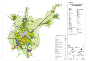
Ghaziabad Master Plan 2031 Map

| Formats | WEBPPDFJPGPNG |
|---|---|
| Height | 1811 px |
| Width | 2560 px |
| Related | Uttar Pradesh Master Plans |
Download High resolution Uttar Pradesh Master Plans Maps in JPG, PDF and PNG formats for free.
Uttar Pradesh is one of the most populous states in India and is home to some of the country’s most important cultural and economic centers. To manage its rapid growth and ensure sustainable development, the state government has created a comprehensive set of Master Plans that outline key priorities and objectives for urban and rural development.
Uttar Pradesh Master Plans are a crucial component of this planning process, providing a detailed overview of land use, infrastructure, and development goals for each district and municipality in the state. These plans are designed to help planners, developers, and policymakers make informed decisions about zoning, transportation, and other key issues that affect the quality of life for residents and the overall economic health of the region.
Uttar Pradesh Master Plans are available in a variety of formats, including digital maps and GIS (Geographic Information System) data. They are often used by developers, real estate professionals, and other stakeholders to assess market opportunities and identify potential areas for investment and development.
In addition to providing valuable information for the private sector, Uttar Pradesh Master Plans are also an important resource for government agencies and public officials. They can help inform decisions about infrastructure investments, land use policies, and other key issues that affect the well-being of communities and the environment.
| Formats | WEBPPDFJPGPNG |
|---|---|
| Height | 1811 px |
| Width | 2560 px |
| Related | Uttar Pradesh Master Plans |

| Formats | WEBPPDFJPGPNG |
|---|---|
| Height | 1795 px |
| Width | 3075 px |
| Related | Uttar Pradesh Master Plans |
| Formats | Multiple Formats |
|---|---|
| Related | Uttar Pradesh Master Plans |

| Formats | WEBPPDFJPGPNG |
|---|---|
| Height | 2412 px |
| Width | 3240 px |
| Related | Uttar Pradesh Master Plans |

| Formats | WEBPPDFJPGPNG |
|---|---|
| Height | 1836 px |
| Width | 2376 px |
| Related | Uttar Pradesh Master Plans, YEIDA Master Plans |

| Formats | WEBPPDFJPGPNG |
|---|---|
| Height | 2384 px |
| Width | 3370 px |
| Related | Uttar Pradesh Master Plans, YEIDA Master Plans |

| Formats | WEBPPDFJPGPNG |
|---|---|
| Height | 2526 px |
| Width | 3576 px |
| Related | Uttar Pradesh Master Plans, YEIDA Master Plans |

| Formats | WEBPPDFJPGPNG |
|---|---|
| Height | 2526 px |
| Width | 3576 px |
| Related | Uttar Pradesh Master Plans, YEIDA Master Plans |

| Formats | WEBPPDFJPGPNG |
|---|---|
| Height | 3024 px |
| Width | 4320 px |
| Related | Uttar Pradesh Master Plans |

| Formats | WEBPPDFJPGPNG |
|---|---|
| Height | 2384 px |
| Width | 3370 px |
| Related | Uttar Pradesh Master Plans |

| Formats | WEBPPDFJPGPNG |
|---|---|
| Height | 3311 px |
| Width | 2339 px |
| Related | Expressway Maps, Uttar Pradesh Master Plans |

| Formats | WEBPPDFJPGPNG |
|---|---|
| Height | 1684 px |
| Width | 1190 px |
| Related | Expressway Maps, Uttar Pradesh Master Plans |

| Formats | WEBPPDFJPGPNG |
|---|---|
| Height | 1684 px |
| Width | 2384 px |
| Related | Uttar Pradesh Master Plans |

| Formats | WEBPPDFJPGPNG |
|---|---|
| Height | 2714 px |
| Width | 3840 px |
| Related | Planning Maps, Uttar Pradesh Master Plans |

| Formats | WEBPPDFJPGPNG |
|---|---|
| Height | 2717 px |
| Width | 3840 px |
| Related | Planning Maps, Uttar Pradesh Master Plans |

| Formats | WEBPPDFJPGPNG |
|---|---|
| Height | 2713 px |
| Width | 3840 px |
| Related | Planning Maps, Uttar Pradesh Master Plans |

| Formats | WEBPPDFJPGPNG |
|---|---|
| Height | 3840 px |
| Width | 2967 px |
| Related | Planning Maps, Uttar Pradesh Master Plans |

| Formats | WEBPPDFJPGPNG |
|---|---|
| Height | 3840 px |
| Width | 3685 px |
| Related | Planning Maps, Uttar Pradesh Master Plans |

| Formats | WEBPPDFJPGPNG |
|---|---|
| Height | 1351 px |
| Width | 3840 px |
| Related | Planning Maps, Uttar Pradesh Master Plans |

| Formats | WEBPPDFJPGPNG |
|---|---|
| Height | 2094 px |
| Width | 3840 px |
| Related | Uttar Pradesh Master Plans |

| Formats | WEBPPDFJPGPNG |
|---|---|
| Height | 3840 px |
| Width | 3447 px |
| Related | Uttar Pradesh Master Plans |

| Formats | WEBPPDFJPGPNG |
|---|---|
| Height | 3366 px |
| Width | 3840 px |
| Related | Uttar Pradesh Master Plans |

| Formats | WEBPPDFJPGPNG |
|---|---|
| Height | 2632 px |
| Width | 3840 px |
| Related | Uttar Pradesh Master Plans |

| Formats | WEBPPDFJPGPNG |
|---|---|
| Height | 2548 px |
| Width | 3840 px |
| Related | Uttar Pradesh Master Plans |
Uttar Pradesh Master Plans are constantly being updated and refined to reflect changes in population, economic trends, and other key factors. This ensures that the state government and its partners have the most up-to-date information available and can make informed decisions about the future of the region. Whether you are a developer, investor, government official, or simply a resident of Uttar Pradesh, Master Plans are an essential resource for understanding the current state of development in the region and planning for a sustainable future. With their detailed information and comprehensive analysis, they are a crucial tool for anyone looking to contribute to the growth and prosperity of this dynamic state.